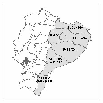
General Study Area Description
Most of the CPC Ecuador Projects have focused on the northern Amazon region Ecuador, but the most recent (and current) study is looking at three areas in the Ecuadorian Andes (provinces of Pichincha, Chimborazo, Cayar and Loja). This map shows the distribution of study sites throughout the country.
Amazonian Study Area Description
The Amazonian work takes place in the westernmost part of the huge Amazon basin. This region, known as the Ecuadorian Oriente, serves as a unique and ecologically significant laboratory for research on human-induced land use and land cover (LULC) dynamics and change associated with growing population settlements. The site contains several areas of extraordinary biodiversity, making it a priority conservation zone. Indeed, the region is considered one of the 11 ecological “hot spots” in the world, so the ongoing deforestation has important implications for biodiversity, resilience, sustainability, and their mediation through government and non-government environmental policies.
The Amazonian study area is primarily contained within two of the northern provinces in the Oriente – Sucumbios and Orellana. The Ecuadorian Amazon in total comprises six provinces – from north to south, Sucumbios, Napo, Orellana, Pastaza, Morona Santiago, and Zamora Chinchipe.
The total estimated population is about 400,000, over two-thirds rural. Rapid population growth has occurred since the early 1970s, with almost half its population born outside the region. Government policies encouraged migration, as the Oriente was perceived as an area with almost infinite space and resources and thus an “escape valve” to relieve socio-economic imbalances in other regions, especially pressures on the land in the Sierra, or Highland. Settlers in the Oriente are small, poor farmers, who have migrated to the region in search of land to support their families, rather than often being large ranchers, as in Brazil. Most have received little or no benefit from government subsidies, credit or agricultural extension. While there is no large-scale timber extraction, much small-scale cutting of trees occurs, on both settler plots and indigenous lands. Having no distinct dry season, little “slash-and-burn” techniques are used; instead “slash-and-mulch” approaches are more commonly followed.
Since 1990, the Oriente has become more densely populated, due to both population growth and to the fact that many large areas have been set-aside as national parks and conservation areas or have been legally titled to indigenous populations. Thus, since then, colonist families have been sub-dividing plots to hand down parcels to their children as well as selling portions to new migrants coming into the region. With the Ecuadorian economy still generally depressed, migrants are still arriving in significant numbers in search of work in the burgeoning towns as well as for a piece of land. Population also continues to grow rapidly from natural population growth, or the excess of fertility over mortality of the existing population. Thus, total fertility rates are much higher than elsewhere in Ecuador, still close to 6 births per woman (vs. 3.3 in the rest of the country, according to the latest national demographic survey in 1999).
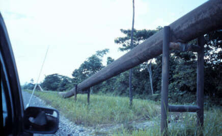
Access to the Oriente was made possible initially by a petroleum boom, which began, in the early 1970’s. Once oil was discovered the oil companies built roads to lay pipelines, which eventually crossed the Andes to the Pacific Coast at Esmeraldas. Since the early 1970’s petroleum has generally provided over one-half of both Ecuador’s merchandise export earnings, and federal government revenues. Once the roads were built, migrant settlers poured in, mostly from the crowed Sierra, expanding the agricultural frontier eastward. In addition to the individual farm dwellings, clusters of dwellings also evolved around major road intersections and petroleum encampments, and sometimes grew into market towns. Lago Agrio (also called Nueva Loja) is the largest city in the region, but still with only about 30,000 people in 2000.
The semi-permeable barriers of the major rivers and internal and external political boundaries shape transport, trade, and communications, as the region borders Colombia and Peru. While the Ecuadorian government facilitated the provision of permanent (“escrituras”) or provisional (“certificados de posesion”) land titles to in-migrant families to encourage settlement in the 1970’s and 1980’s through the Instituto de Reforma Agraria y Colonizacion (IERAC), IERAC was eliminated and replaced by another far weaker government agency, INDA, in 1993, so most new arrivals and children inheriting plots do not have legal land titles. The resulting increased insecurity of land titles may be influencing subsequent land use practices in new ways, as well as the permanence of migrant settlement.
Recent History of the Amazonian Frontier Region
Beginning in the early 1970s, petroleum companies built roads into the northern Oriente for oil exploration, and pipelines for oil extraction. Once the region became accessible through the road network, colonists migrated to the region from other parts of Ecuador in search of land, even in the absence of any direct government incentives. Forests were cleared and agricultural crops cultivated for both subsistence and sale to the market. Land along roads was most coveted, because of its geographic accessibility to newly emerging service and market towns. After the land along the main roads was settled, additional roads and paths were built farther into the forest, parallel to the main roads and approximately 2 km apart. These parallel roads, or lineas, were then settled by the constant influx of in-migrants. The lineas can extend as far as 16 km from the main roads, with footpaths being the only means of accessibility in some cases. Most farms when initially settled comprised roughly 50 hectares in size (250 meters wide, by 2000 meters long), resulting in the classic fishbone pattern of land clearing. In recent years, as much of the unsettled land has disappeared, farmers have begun subdividing their farms, giving or selling portions to family members and new in-migrants.
In this study, the area that has been settled by these migrants is referred to as the colonist study area. Small-scale farmers have been the primary direct agents of land conversion from forest to agriculture in Ecuador. Intensification of land use has overtaken extensification of land use, and this can be seen in a variety of ways. First, the population continues to increase in the region. Second, the increasing population is settling on smaller parcels of land, which as being subdivided from the larger finca madres (the original 50 ha farms). This results in more people living on the same plots of land and utilizing more of that land, thereby leaving less land in forest. Third, the designation of national parks and other federally owned lands leaves less land for new settlement.
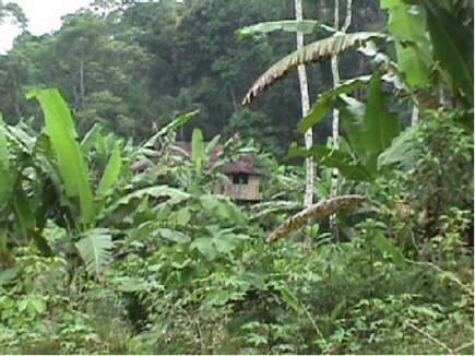
The colonist farmers are converting the forest into agricultural plots and pastures. The largest cash crop in the region is coffee, with other crops including banana, African palm and palmito, cacao, sugar cane, corn, rice and yuca. Pastures are being cleared for the raising of livestock. Most livestock farmers raise cattle, although some also raise goats.
Several towns and cities have developed in the northern Oriente, primarily to serve the oil industry. The two largest cities in this region are Lago Agrio, the provincial capital of Sucumbios, and Coca, the provincial capital of Orellana. Several smaller towns fill similar functions throughout these two provinces, including Shushufindi and La Joya de los Sachas. These “urban” centers provide much of the developed infrastructure in the territory.
To the east and south of the colonist area, vast tracts of relatively pristine tropical Amazonian rainforest still exist. A large amount of this rainforest is contained within two protected areas: the Reserva de Producción Faunística Cuyabeno (Cuyabeno Wildlife Reserve) and the Parque Nacional Yasuní (Yasuní National Park).
Indigenous groups live in and around the two reserves, and scattered throughout the colonist area as well. Five main indigenous groups inhabit this region: Cofán, Huaorani, Quichua, Siona-Secoya, and Shuar. These groups lived here for centuries prior to the influx of colonists. Most still follow their traditional land use practices, although many are becoming involved in the economic activities of the region, growing crops for sell and trade at nearby towns. The vast majority of the indigenous villages in the Oriente are on rivers, rather than roads, illustrating that these groups still rely on rivers for their primary transportation.