Fractional cover (FC) is the percentage of vegetative cover on the ground. In the context of a remotely-sensed image, the FC values represent the percentage of vegetative cover present in each pixel.
Fractional cover is derived from the Normalized Difference Vegetation Index (NDVI). The equation is
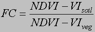
where VIsoil is the NDVI value of a pixel containing 0% vegetative cover, and VI veg is the NDVI value of a pixel containing 100% vegetative cover.
Once a value has been determined for each of the two variables, the FC formula is applied to the NDVI image as an algorithm which outputs a preliminary FC image (FCprelim ). This preliminary image is then modified so that it ranges from 0 to 1. Due to the well-documented nature of NDVI saturating at the upper end in tropical environments, it is quite common to end up with FCprelim values greater than 1. It is also common to have FCprelim values below 0, as the NDVI of water can be less than bare soil. Therefore, we are working under the assumption that our VI soil and VIveg values are accurate. So rather than stretching the values to fit between 0 and 1, we simply change all negative FCprelimvalues to 0 and all FCprelim values greater than 1 to 1.
Fractional cover has been generated for every TM image that has been classified. Up to this point, it’s primarily been used to add a bit of additional detail to the generalized classifications in the Path 8/Row 60 and Path 9/Row 61 classifications. Through the use of FC, we have been able to expand the Agriculture/Pasture class to Agriculture, Sparse Agriculture, Pasture, and Agriculture/Pasture (for those areas where we are unsure). We have also been able to split the Forest class into as many as 20 different classes with differing levels of canopy density. This provides us with more information than previously available.